
- Startseite >
- Flüsse >
- Wasserstand >
- Bayern >
- Gampelmühle >
- Jahresgrafik

Jahresgrafik Gampelmühle / Ölschnitz
Wasserstand vom 01.01.2019 bis zum 31.12.2019
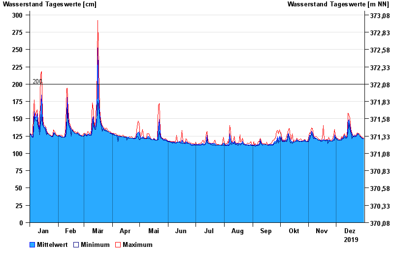
- 200 cm: Gampelmühle: Beidseitige Ausuferung im Wiesengelände unterhalb der Pegelstelle.
- 335 cm: Gampelmühle: Einzelanwesen Hesselweg
- 335 cm: Hauendorf: Garagen
- 370 cm: Gampelmühle: beginnende Überflutung der Ortsanbindung von Neukirchen am Main.
- 380 cm: Gampelmühle: Kläranlage
| Datum | Mittelwert [cm] | Maximum [cm] | Minimum [cm] |
|---|---|---|---|
| 31.12.2019 | 121 | 122 | 121 |
| 30.12.2019 | 122 | 123 | 121 |
| 29.12.2019 | 122 | 123 | 122 |
| 28.12.2019 | 123 | 124 | 123 |
| 27.12.2019 | 125 | 126 | 124 |
| 26.12.2019 | 126 | 128 | 126 |
| 25.12.2019 | 128 | 129 | 128 |
© Bayerisches Landesamt für Umwelt 2025