
- Startseite >
- Flüsse >
- Wasserstand >
- Bayern >
- Schlehenmühle >
- Jahresgrafik

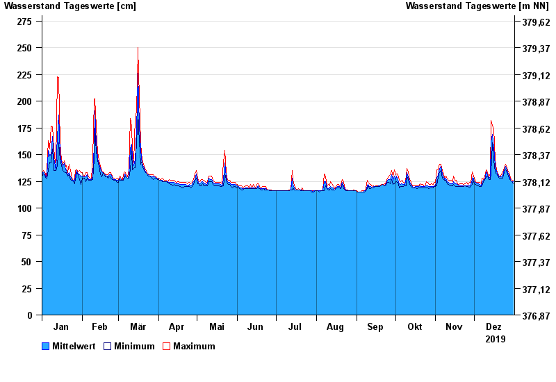
Jahresgrafik Schlehenmühle / Roter Main
Wasserstand vom 01.01.2019 bis zum 31.12.2019
- 26.01.1995 Wasserstand: 399 cm
- 23.12.1967 Wasserstand: 387 cm
- 23.02.1970 Wasserstand: 385 cm
- 06.06.1984 Wasserstand: 363 cm
- 15.01.1968 Wasserstand: 355 cm
| Datum | Mittelwert [cm] | Maximum [cm] | Minimum [cm] |
|---|---|---|---|
| 31.12.2019 | 125 | 126 | 123 |
| 30.12.2019 | 125 | 126 | 125 |
| 29.12.2019 | 126 | 128 | 126 |
| 28.12.2019 | 129 | 131 | 127 |
| 27.12.2019 | 132 | 134 | 130 |
| 26.12.2019 | 136 | 138 | 134 |
| 25.12.2019 | 139 | 141 | 136 |
© Bayerisches Landesamt für Umwelt 2025