
- Startseite >
- Grundwasser >
- Wasserstand oberes Stockwerk >
- Bayern >
- Pörndorf ost >
- Gesamtzeitraum

Gesamtzeitraum Pörndorf ost
Grundwasserstände im Gesamtzeitraum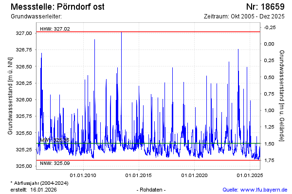
Hinweis
GW Messstelle im SN Flussraum Vils
Grundwasserstand [m ü. NN]: 325,23
Flurabstand [m u. Gelände]: 1,61
Letzter Messwert vom 06.02.2025 11:00
Geländehöhe [m ü. NN]: 326,84
| Datum | Grundwasserstand [m ü. NN] |
|---|---|
| 05.02.2025 | 325,25 |
| 04.02.2025 | 325,27 |
| 03.02.2025 | 325,30 |
| 02.02.2025 | 325,33 |
| 01.02.2025 | 325,36 |
| 31.01.2025 | 325,41 |
| 30.01.2025 | 325,46 |
| 29.01.2025 | 325,36 |
© Bayerisches Landesamt für Umwelt 2025