
- Startseite >
- Grundwasser >
- Wasserstand oberes Stockwerk >
- Bayern >
- Treuchtlingen-Dietfurt >
- Gesamtzeitraum

Gesamtzeitraum Treuchtlingen-Dietfurt
Grundwasserstände im Gesamtzeitraum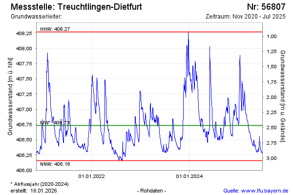
Grundwasserstand [m ü. NN]: 407,68
Flurabstand [m u. Gelände]: 1,52
Letzter Messwert vom 16.01.2025 10:00
Geländehöhe [m ü. NN]: 409,20
Datum | Grundwasserstand [m ü. NN] |
|---|---|
| 16.01.2025 | 407,70 |
| 15.01.2025 | 407,77 |
| 14.01.2025 | 407,85 |
| 13.01.2025 | 407,89 |
| 12.01.2025 | 407,86 |
| 11.01.2025 | 407,77 |
| 10.01.2025 | 407,61 |
| 09.01.2025 | 407,36 |
© Bayerisches Landesamt für Umwelt 2025