
- Startseite >
- Grundwasser >
- Wasserstand oberes Stockwerk >
- Bayern >
- Wieshaid B6 >
- Gesamtzeitraum

Gesamtzeitraum Wieshaid B6
Grundwasserstände im Gesamtzeitraum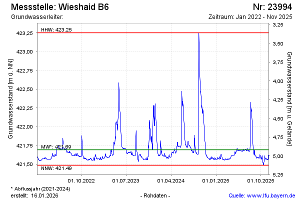
Grundwasserstand [m ü. NN]: 421,58
Flurabstand [m u. Gelände]: 5,03
Letzter Messwert vom 20.11.2024 09:00
Geländehöhe [m ü. NN]: 426,61
| Datum | Grundwasserstand [m ü. NN] |
|---|---|
| 20.11.2024 | 421,58 |
| 19.11.2024 | 421,58 |
| 18.11.2024 | 421,58 |
| 17.11.2024 | 421,58 |
| 16.11.2024 | 421,58 |
| 15.11.2024 | 421,58 |
| 14.11.2024 | 421,58 |
| 13.11.2024 | 421,58 |
© Bayerisches Landesamt für Umwelt 2024