
- Startseite >
- Grundwasser >
- Wasserstand oberes Stockwerk >
- Isar >
- PLANTAGENWEG 96 >
- Gesamtzeitraum

Gesamtzeitraum PLANTAGENWEG 96
Grundwasserstände im Gesamtzeitraum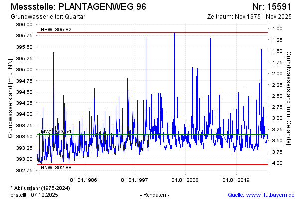
Grundwasserstand [m ü. NN]: 393,56
Flurabstand [m u. Gelände]: 3,35
Letzter Messwert vom 07.01.2025 14:10
Geländehöhe [m ü. NN]: 396,91
| Datum | Grundwasserstand [m ü. NN] |
|---|---|
| 07.01.2025 | 393,55 |
| 06.01.2025 | 393,51 |
| 05.01.2025 | 393,49 |
| 04.01.2025 | 393,49 |
| 03.01.2025 | 393,49 |
| 02.01.2025 | 393,50 |
| 01.01.2025 | 393,51 |
| 31.12.2024 | 393,52 |
© Bayerisches Landesamt für Umwelt 2025