
- Startseite >
- Grundwasser >
- Wasserstand oberes Stockwerk >
- Isar >
- SENDLING 301 >
- Gesamtzeitraum

Gesamtzeitraum SENDLING 301
Grundwasserstände im Gesamtzeitraum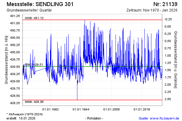
Grundwasserstand [m ü. NN]: 429,38
Flurabstand [m u. Gelände]: 1,51
Letzter Messwert vom 16.02.2025 07:00
Geländehöhe [m ü. NN]: 430,89
| Datum | Grundwasserstand [m ü. NN] |
|---|---|
| 15.02.2025 | 429,38 |
| 14.02.2025 | 429,39 |
| 13.02.2025 | 429,39 |
| 12.02.2025 | 429,40 |
| 11.02.2025 | 429,41 |
| 10.02.2025 | 429,42 |
| 09.02.2025 | 429,43 |
| 08.02.2025 | 429,45 |
© Bayerisches Landesamt für Umwelt 2025