
- Startseite >
- Grundwasser >
- Wasserstand oberes Stockwerk >
- Untere Donau >
- OTTMARING_OP14 >
- Gesamtzeitraum

Gesamtzeitraum OTTMARING_OP14
Grundwasserstände im Gesamtzeitraum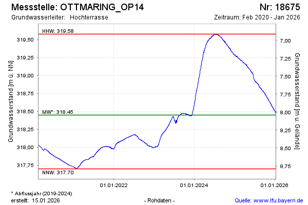
Grundwasserstand [m ü. NN]: 319,23
Flurabstand [m u. Gelände]: 7,26
Letzter Messwert vom 15.02.2025 08:00
Geländehöhe [m ü. NN]: 326,49
| Datum | Grundwasserstand [m ü. NN] |
|---|---|
| 15.02.2025 | 319,23 |
| 14.02.2025 | 319,23 |
| 13.02.2025 | 319,23 |
| 12.02.2025 | 319,24 |
| 11.02.2025 | 319,24 |
| 10.02.2025 | 319,24 |
| 09.02.2025 | 319,24 |
| 08.02.2025 | 319,24 |
© Bayerisches Landesamt für Umwelt 2025