
- Startseite >
- Grundwasser >
- Wasserstand oberes Stockwerk >
- Untere Donau >
- Walchsing Ort >
- Gesamtzeitraum

Gesamtzeitraum Walchsing Ort
Grundwasserstände im Gesamtzeitraum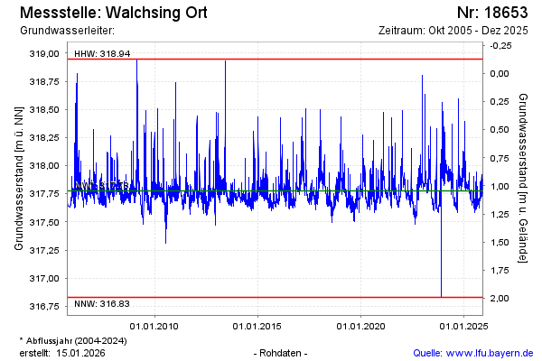
Hinweis
GW Messtelle im SN Flussraum Vils
Grundwasserstand [m ü. NN]: 317,90
Flurabstand [m u. Gelände]: 0,92
Letzter Messwert vom 06.02.2025 11:00
Geländehöhe [m ü. NN]: 318,82
| Datum | Grundwasserstand [m ü. NN] |
|---|---|
| 05.02.2025 | 317,89 |
| 04.02.2025 | 317,89 |
| 03.02.2025 | 317,92 |
| 02.02.2025 | 317,94 |
| 01.02.2025 | 317,96 |
| 31.01.2025 | 318,01 |
| 30.01.2025 | 318,07 |
| 29.01.2025 | 317,96 |
© Bayerisches Landesamt für Umwelt 2025