
- Startseite >
- Grundwasser >
- Wasserstand tiefere Stockwerke >
- Bayern >
- ADELSRIED TA 1-T2 >
- Gesamtzeitraum

Gesamtzeitraum ADELSRIED TA 1-T2
Grundwasserstände im Gesamtzeitraum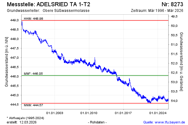
Grundwasserstand [m ü. NN]: 444,89
Flurabstand [m u. Gelände]: 53,81
Letzter Messwert vom 19.11.2024 14:00
Geländehöhe [m ü. NN]: 498,70
| Datum | Grundwasserstand [m ü. NN] |
|---|---|
| 19.11.2024 | 444,87 |
| 18.11.2024 | 444,84 |
| 17.11.2024 | 444,84 |
| 16.11.2024 | 444,81 |
| 15.11.2024 | 444,79 |
| 14.11.2024 | 444,79 |
| 13.11.2024 | 444,78 |
| 12.11.2024 | 444,79 |
© Bayerisches Landesamt für Umwelt 2024