
- Startseite >
- Grundwasser >
- Wasserstand tiefere Stockwerke >
- Obere Donau >
- ROEDENHOF T 7 >
- Gesamtzeitraum

Gesamtzeitraum ROEDENHOF T 7
Grundwasserstände im Gesamtzeitraum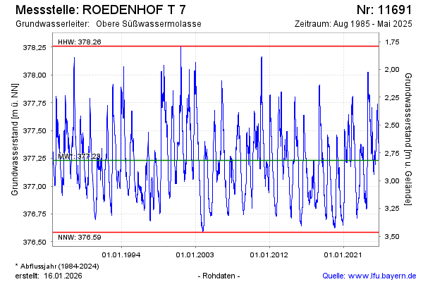
Grundwasserstand [m ü. NN]: 377,31
Flurabstand [m u. Gelände]: 2,74
Letzter Messwert vom 21.10.2024 09:00
Geländehöhe [m ü. NN]: 380,05
| Datum | Grundwasserstand [m ü. NN] |
|---|---|
| 21.10.2024 | 377,31 |
| 20.10.2024 | 377,31 |
| 19.10.2024 | 377,32 |
| 18.10.2024 | 377,32 |
| 17.10.2024 | 377,32 |
| 16.10.2024 | 377,32 |
| 15.10.2024 | 377,31 |
| 14.10.2024 | 377,30 |
© Bayerisches Landesamt für Umwelt 2025