
- Startseite >
- Grundwasser >
- Wasserstand tiefere Stockwerke >
- Untere Donau >
- ALTDORF TIEFBOHRUNG >
- Gesamtzeitraum

Gesamtzeitraum ALTDORF TIEFBOHRUNG
Grundwasserstände im Gesamtzeitraum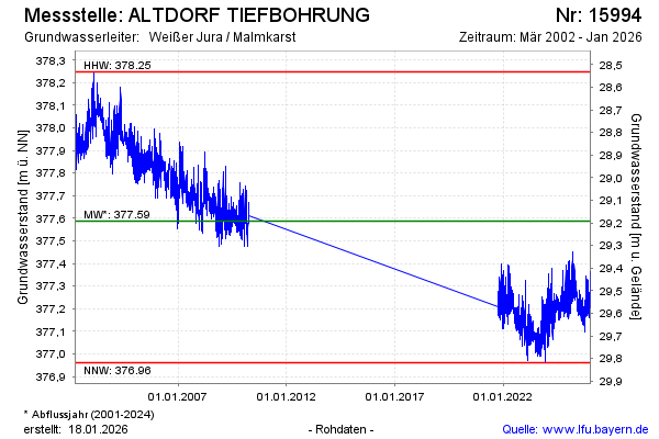
Hinweis
Keine Beobachtung von 04/2010 bis 09/2021
Grundwasserstand [m ü. NN]: 377,25
Flurabstand [m u. Gelände]: 29,53
Letzter Messwert vom 26.11.2024 10:00
Geländehöhe [m ü. NN]: 406,78
| Datum | Grundwasserstand [m ü. NN] |
|---|---|
| 26.11.2024 | 377,27 |
| 25.11.2024 | 377,28 |
| 24.11.2024 | 377,25 |
| 23.11.2024 | 377,25 |
| 22.11.2024 | 377,36 |
| 21.11.2024 | 377,39 |
| 20.11.2024 | 377,39 |
| 19.11.2024 | 377,37 |
© Bayerisches Landesamt für Umwelt 2024