
- Startseite >
- Grundwasser >
- Wasserstand tiefere Stockwerke >
- Untere Donau >
- BRUNNEN / POSTAU 1 T16 >
- Gesamtzeitraum

Gesamtzeitraum BRUNNEN / POSTAU 1 T16
Grundwasserstände im Gesamtzeitraum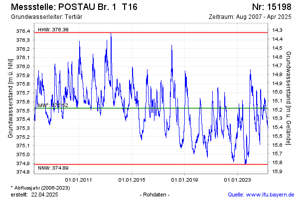
Grundwasserstand [m ü. NN]: 375,39
Flurabstand [m u. Gelände]: 15,32
Letzter Messwert vom 15.03.2025 10:00
Geländehöhe [m ü. NN]: 390,71
| Datum | Grundwasserstand [m ü. NN] |
|---|---|
| 15.03.2025 | 375,39 |
| 14.03.2025 | 375,41 |
| 13.03.2025 | 375,42 |
| 12.03.2025 | 375,43 |
| 11.03.2025 | 375,43 |
| 10.03.2025 | 375,43 |
| 09.03.2025 | 375,44 |
| 08.03.2025 | 375,43 |
© Bayerisches Landesamt für Umwelt 2025