
- Start >
- Groundwater >
- Waterlevel of deep layer >
- Bayern >
- PENESLOHE AM-KMS-2 >
- Chart of total period

Chart of total period PENESLOHE AM-KMS-2
Groundwater levels of the total period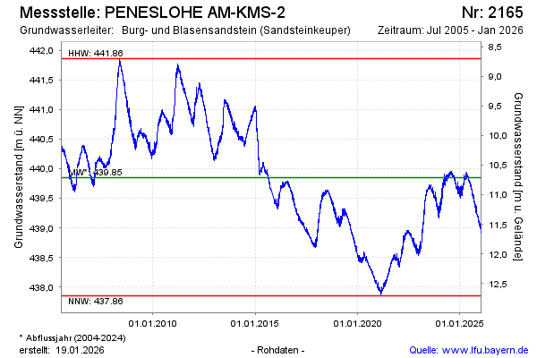
Groundwater level [m above sealevel]: 439.83
Distance to surface [m]: 10.73
Last value from 09.10.2024 07:35
Ground level [m above sealevel]: 450.56
| Date | Groundwater level [m above sealevel] |
|---|---|
| 07.10.2024 | 439.83 |
| 06.10.2024 | 439.81 |
| 05.10.2024 | 439.80 |
| 04.10.2024 | 439.81 |
| 03.10.2024 | 439.82 |
| 02.10.2024 | 439.85 |
| 01.10.2024 | 439.82 |
| 30.09.2024 | 439.79 |
© Bayerisches Landesamt für Umwelt 2024