
- Start >
- Groundwater >
- Waterlevel of deep layer >
- Bayern >
- TAUFKIRCHEN B. MUE. >
- Chart of total period

Chart of total period TAUFKIRCHEN B. MUE.
Groundwater levels of the total period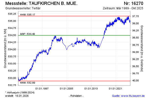
note
Datenaktualisierung erfolgt quartalsweise
Groundwater level [m above sealevel]: 535.12
Distance to surface [m]: 37.79
Last value from 30.01.2025 14:00
Ground level [m above sealevel]: 572.91
| Date | Groundwater level [m above sealevel] |
|---|---|
| 30.01.2025 | 535.12 |
| 29.01.2025 | 535.14 |
| 28.01.2025 | 535.16 |
| 27.01.2025 | 535.15 |
| 26.01.2025 | 535.13 |
| 25.01.2025 | 535.13 |
| 24.01.2025 | 535.12 |
| 23.01.2025 | 535.14 |
© Bayerisches Landesamt für Umwelt 2025