
- Start >
- Groundwater >
- Waterlevel of deep layer >
- Oberer Main - Elbe >
- HOHENZELL T 6f >
- Chart of total period

Chart of total period HOHENZELL T 6f
Groundwater levels of the total period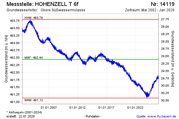
Groundwater level [m above sealevel]: 491.66
Distance to surface [m]: 29.89
Last value from 12.03.2025 09:00
Ground level [m above sealevel]: 521.55
| Date | Groundwater level [m above sealevel] |
|---|---|
| 13.03.2025 | 491.66 |
| 12.03.2025 | 491.66 |
| 11.03.2025 | 491.64 |
| 10.03.2025 | 491.66 |
| 09.03.2025 | 491.67 |
| 08.03.2025 | 491.65 |
| 07.03.2025 | 491.63 |
| 06.03.2025 | 491.62 |
© Bayerisches Landesamt für Umwelt 2025