
- Start >
- Groundwater >
- Waterlevel of deep layer >
- Iller - Lech - Bodensee >
- Lohhof GS2 >
- Chart of total period

Chart of total period Lohhof GS2
Groundwater levels of the total period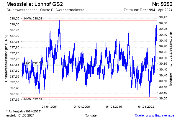
Groundwater level [m above sealevel]: 537.96
Distance to surface [m]: 39.05
Last value from 22.11.2024 09:00
Ground level [m above sealevel]: 577.01
| Date | Groundwater level [m above sealevel] |
|---|---|
| 22.11.2024 | 537.99 |
| 21.11.2024 | 537.99 |
| 20.11.2024 | 537.98 |
| 19.11.2024 | 537.97 |
| 18.11.2024 | 537.93 |
| 17.11.2024 | 537.92 |
| 16.11.2024 | 537.90 |
| 15.11.2024 | 537.88 |
© Bayerisches Landesamt für Umwelt 2024