
- Start >
- Groundwater >
- Waterlevel of deep layer >
- Untere Donau >
- AUTOBAHN WÖRTH/ISAR W3 >
- Chart of total period

Chart of total period AUTOBAHN WÖRTH/ISAR W3
Groundwater levels of the total period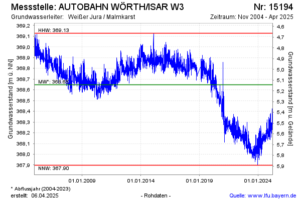
Groundwater level [m above sealevel]: 368.34
Distance to surface [m]: 5.45
Last value from 29.03.2025 10:00
Ground level [m above sealevel]: 373.79
Date | Groundwater level [m above sealevel] |
|---|---|
| 29.03.2025 | 368.36 |
| 28.03.2025 | 368.34 |
| 27.03.2025 | 368.30 |
| 26.03.2025 | 368.30 |
| 25.03.2025 | 368.30 |
| 24.03.2025 | 368.33 |
| 23.03.2025 | 368.38 |
| 22.03.2025 | 368.36 |
© Bayerisches Landesamt für Umwelt 2025