
- Start >
- Groundwater >
- Waterlevel of deep layer >
- Untere Donau >
- Bruderamming >
- Chart of total period

Chart of total period Bruderamming
Groundwater levels of the total period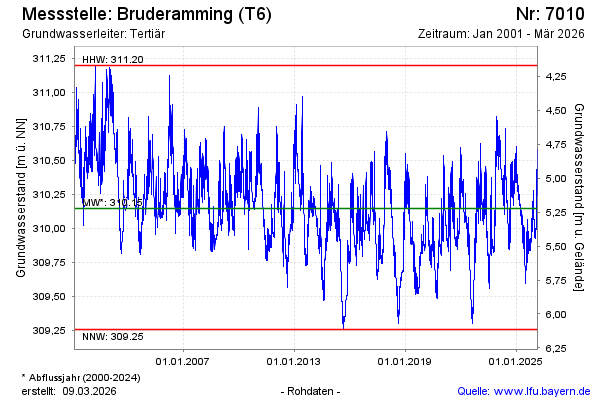
note
GW Messstelle im Grundnetz
Groundwater level [m above sealevel]: 309.49
Distance to surface [m]: 5.88
Last value from 13.03.2025 18:11
Ground level [m above sealevel]: 315.37
| Date | Groundwater level [m above sealevel] |
|---|---|
| 13.03.2025 | 309.46 |
| 12.03.2025 | 309.44 |
| 11.03.2025 | 309.44 |
| 10.03.2025 | 309.44 |
| 09.03.2025 | 309.44 |
| 08.03.2025 | 309.44 |
| 07.03.2025 | 309.44 |
| 06.03.2025 | 309.44 |
© Bayerisches Landesamt für Umwelt 2025