
- Start >
- Groundwater >
- Waterlevel of deep layer >
- Untere Donau >
- BRUNNEN VII KOHLSTORF >
- Chart of total period

Chart of total period BRUNNEN VII KOHLSTORF
Groundwater levels of the total period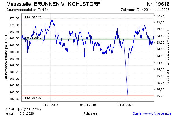
Groundwater level [m above sealevel]: 369.90
Distance to surface [m]: 23.20
Last value from 12.01.2025 08:00
Ground level [m above sealevel]: 393.10
| Date | Groundwater level [m above sealevel] |
|---|---|
| 12.01.2025 | 369.90 |
| 11.01.2025 | 369.92 |
| 10.01.2025 | 369.94 |
| 09.01.2025 | 369.97 |
| 08.01.2025 | 369.96 |
| 07.01.2025 | 369.97 |
| 06.01.2025 | 369.99 |
| 05.01.2025 | 369.98 |
© Bayerisches Landesamt für Umwelt 2025