
- Start >
- Groundwater >
- Waterlevel of deep layer >
- Untere Donau >
- Mitterhartshausen T2 >
- Current data

Current data Mitterhartshausen T2
Groundwater levels of the last 12 months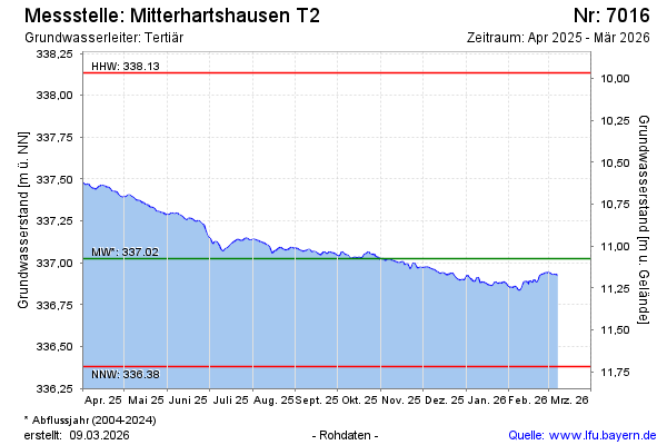
note
GW Messstelle im Grundnetz
Groundwater level [m above sealevel]: 337.45
Distance to surface [m]: 10.65
Last value from 18.10.2024 08:00
Ground level [m above sealevel]: 348.10
| Date | Groundwater level [m above sealevel] |
|---|---|
| 18.10.2024 | 337.45 |
| 17.10.2024 | 337.45 |
| 16.10.2024 | 337.44 |
| 15.10.2024 | 337.43 |
| 14.10.2024 | 337.42 |
| 13.10.2024 | 337.43 |
| 12.10.2024 | 337.44 |
| 11.10.2024 | 337.44 |
© Bayerisches Landesamt für Umwelt 2024