
- Start >
- Groundwater >
- Waterlevel of upper layer >
- Bayern >
- ARNULFSTR. 6A >
- Chart of total period

Chart of total period ARNULFSTR. 6A
Groundwater levels of the total period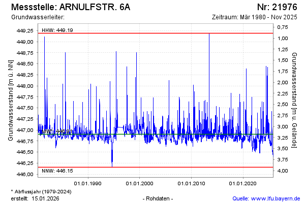
note
Die Messstelle musste 1996 verlegt werden !
Groundwater level [m above sealevel]: 447.09
Distance to surface [m]: 2.99
Last value from 09.01.2025 13:00
Ground level [m above sealevel]: 450.08
| Date | Groundwater level [m above sealevel] |
|---|---|
| 09.01.2025 | 447.10 |
| 08.01.2025 | 447.14 |
| 07.01.2025 | 447.14 |
| 06.01.2025 | 447.11 |
| 05.01.2025 | 446.90 |
| 04.01.2025 | 446.82 |
| 03.01.2025 | 446.83 |
| 02.01.2025 | 446.83 |
© Bayerisches Landesamt für Umwelt 2025