
- Start >
- Groundwater >
- Waterlevel of upper layer >
- Bayern >
- BAD AIBLING TRIFTB._52A >
- Current data

Current data BAD AIBLING TRIFTB._52A
Groundwater levels of the last 12 months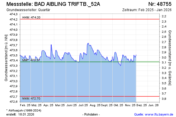
note
Die Messstelle musste 2007 verlegt werden !
Groundwater level [m above sealevel]: 473.53
Distance to surface [m]: 2.93
Last value from 20.11.2024 13:24
Ground level [m above sealevel]: 476.46
| Date | Groundwater level [m above sealevel] |
|---|---|
| 20.11.2024 | 473.52 |
| 19.11.2024 | 473.51 |
| 18.11.2024 | 473.51 |
| 17.11.2024 | 473.49 |
| 16.11.2024 | 473.50 |
| 15.11.2024 | 473.51 |
| 14.11.2024 | 473.52 |
| 13.11.2024 | 473.51 |
© Bayerisches Landesamt für Umwelt 2024