
- Start >
- Groundwater >
- Waterlevel of upper layer >
- Bayern >
- Birkenfeld WÜ - MU 1 >
- Chart of total period

Chart of total period Birkenfeld WÜ - MU 1
Groundwater levels of the total period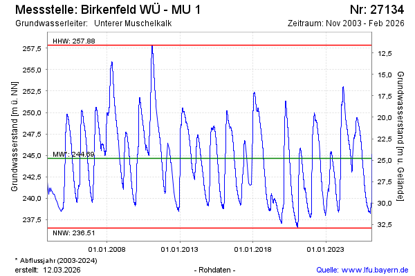
note
Datenfernübertragung ist nicht stabil. Messwerte werden monatlich ausgelesen.
Groundwater level [m above sealevel]: 247.05
Distance to surface [m]: 22.39
Last value from 05.12.2024 13:00
Ground level [m above sealevel]: 269.44
| Date | Groundwater level [m above sealevel] |
|---|---|
| 05.12.2024 | 247.02 |
| 04.12.2024 | 247.02 |
| 03.12.2024 | 247.06 |
| 02.12.2024 | 247.07 |
| 01.12.2024 | 247.02 |
| 30.11.2024 | 246.98 |
| 29.11.2024 | 246.94 |
| 28.11.2024 | 246.97 |
© Bayerisches Landesamt für Umwelt 2024