
- Start >
- Groundwater >
- Waterlevel of upper layer >
- Bayern >
- BURLAFINGEN 14 >
- Chart of total period

Chart of total period BURLAFINGEN 14
Groundwater levels of the total period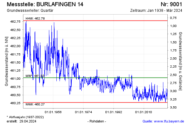
note
Aktualisierung nur alle 3 Monate!
Groundwater level [m above sealevel]: 460.49
Distance to surface [m]: 3.13
Last value from 23.09.2024 13:00
Ground level [m above sealevel]: 463.62
| Date | Groundwater level [m above sealevel] |
|---|---|
| 17.09.2024 | 460.51 |
| 03.09.2024 | 460.44 |
| 27.08.2024 | 460.48 |
| 20.08.2024 | 460.55 |
| 06.08.2024 | 460.54 |
| 30.07.2024 | 460.48 |
| 24.07.2024 | 460.51 |
| 17.07.2024 | 460.52 |
© Bayerisches Landesamt für Umwelt 2025