
- Start >
- Groundwater >
- Waterlevel of upper layer >
- Bayern >
- Dollnstein >
- Current data

Current data Dollnstein
Groundwater levels of the last 12 months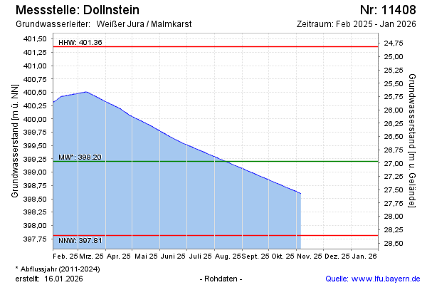
note
Datenübertragung Defekt. Daten werden manuel Ausgelesen
Groundwater level [m above sealevel]: 397.91
Distance to surface [m]: 28.26
Last value from 19.12.2024 09:00
Ground level [m above sealevel]: 426.17
| Date | Groundwater level [m above sealevel] |
|---|---|
| 19.12.2024 | 397.91 |
| 18.12.2024 | 397.91 |
| 17.12.2024 | 397.91 |
| 16.12.2024 | 398.89 |
| 15.12.2024 | 399.97 |
| 14.12.2024 | 399.98 |
| 13.12.2024 | 399.97 |
| 12.12.2024 | 399.96 |
© Bayerisches Landesamt für Umwelt 2025