
- Start >
- Groundwater >
- Waterlevel of upper layer >
- Bayern >
- Endinger Loch >
- Chart of total period

Chart of total period Endinger Loch
Groundwater levels of the total period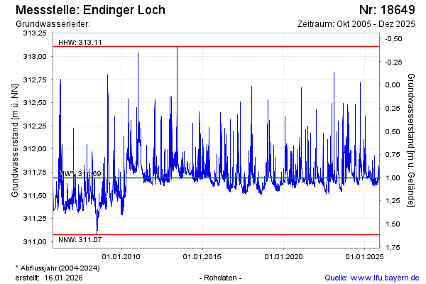
note
GW Messtelle im SN Flussraum Vils
Groundwater level [m above sealevel]: 311.78
Distance to surface [m]: 0.91
Last value from 22.08.2024 12:30
Ground level [m above sealevel]: 312.69
| Date | Groundwater level [m above sealevel] |
|---|---|
| 22.08.2024 | 311.78 |
| 21.08.2024 | 311.80 |
| 20.08.2024 | 311.88 |
| 19.08.2024 | 311.86 |
| 18.08.2024 | 311.72 |
| 17.08.2024 | 311.67 |
| 16.08.2024 | 311.66 |
| 15.08.2024 | 311.65 |
© Bayerisches Landesamt für Umwelt 2024