
- Start >
- Groundwater >
- Waterlevel of upper layer >
- Bayern >
- Flussraummanagement Vils, MQS 03-L (ML03) >
- Chart of total period

Chart of total period Flussraummanagement Vils, MQS 03-L (ML03)
Groundwater levels of the total period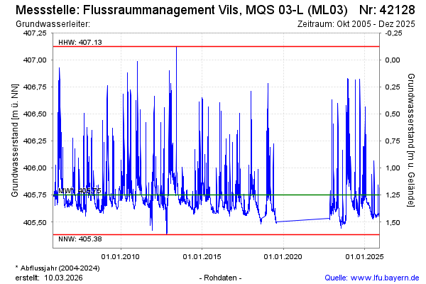
Groundwater level [m above sealevel]: 405.63
Distance to surface [m]: 1.37
Last value from 11.11.2024 10:30
Ground level [m above sealevel]: 407.00
| Date | Groundwater level [m above sealevel] |
|---|---|
| 11.11.2024 | 405.63 |
| 10.11.2024 | 405.64 |
| 09.11.2024 | 405.65 |
| 08.11.2024 | 405.64 |
| 07.11.2024 | 405.64 |
| 06.11.2024 | 405.64 |
| 05.11.2024 | 405.65 |
| 04.11.2024 | 405.65 |
© Bayerisches Landesamt für Umwelt 2025