
- Start >
- Groundwater >
- Waterlevel of upper layer >
- Bayern >
- Flussraummanagement Vils ZA 21 >
- Chart of total period

Chart of total period Flussraummanagement Vils ZA 21
Groundwater levels of the total period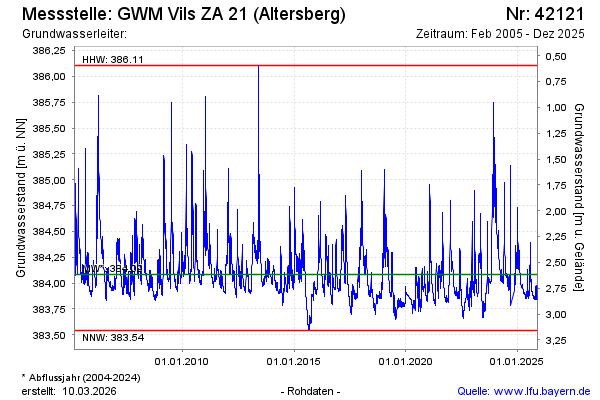
Groundwater level [m above sealevel]: 384.09
Distance to surface [m]: 2.61
Last value from 25.11.2024 09:55
Ground level [m above sealevel]: 386.70
| Date | Groundwater level [m above sealevel] |
|---|---|
| 25.11.2024 | 384.09 |
| 24.11.2024 | 384.09 |
| 23.11.2024 | 384.09 |
| 22.11.2024 | 384.08 |
| 21.11.2024 | 384.03 |
| 20.11.2024 | 383.93 |
| 12.11.2024 | 382.82 |
| 11.11.2024 | 382.81 |
© Bayerisches Landesamt für Umwelt 2024