
- Start >
- Groundwater >
- Waterlevel of upper layer >
- Bayern >
- FORSTHAUS GRUB 174 >
- Chart of total period

Chart of total period FORSTHAUS GRUB 174
Groundwater levels of the total period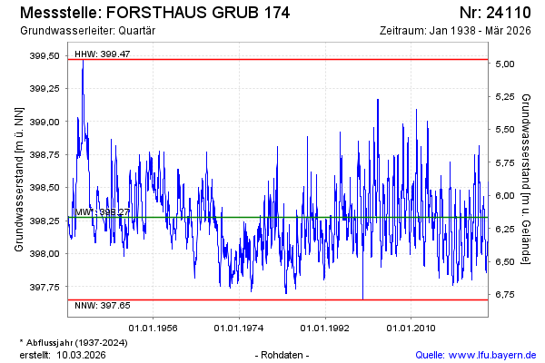
note
DFÜ-Störung, Daten nicht verfügbar
Groundwater level [m above sealevel]: 398.13
Distance to surface [m]: 6.31
Last value from 04.11.2024 11:59
Ground level [m above sealevel]: 404.44
| Date | Groundwater level [m above sealevel] |
|---|---|
| 04.11.2024 | 398.92 |
| 03.11.2024 | 398.95 |
| 02.11.2024 | 398.96 |
| 01.11.2024 | 398.96 |
| 31.10.2024 | 398.96 |
| 30.10.2024 | 398.96 |
| 29.10.2024 | 398.96 |
| 28.10.2024 | 398.98 |
© Bayerisches Landesamt für Umwelt 2024