
- Start >
- Groundwater >
- Waterlevel of upper layer >
- Bayern >
- FORSTINNING 511 >
- Chart of total period

Chart of total period FORSTINNING 511
Groundwater levels of the total period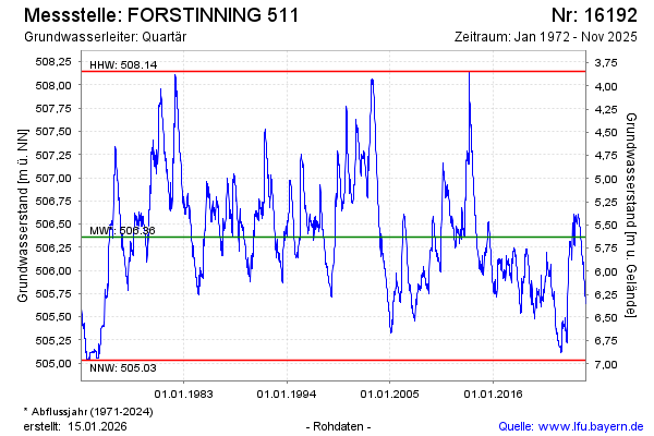
note
Die Messstelle wird wöchentlich beobachtet.
Groundwater level [m above sealevel]: 506.30
Distance to surface [m]: 5.69
Last value from 25.08.2024 10:00
Ground level [m above sealevel]: 511.99
| Date | Groundwater level [m above sealevel] |
|---|---|
| 18.08.2024 | 506.32 |
| 11.08.2024 | 506.28 |
| 04.08.2024 | 506.61 |
| 28.07.2024 | 506.35 |
| 21.07.2024 | 506.36 |
| 14.07.2024 | 506.38 |
| 07.07.2024 | 506.39 |
| 30.06.2024 | 506.37 |
© Bayerisches Landesamt für Umwelt 2024