
- Start >
- Groundwater >
- Waterlevel of upper layer >
- Bayern >
- G13 HRB Feldolling >
- Chart of total period

Chart of total period G13 HRB Feldolling
Groundwater levels of the total period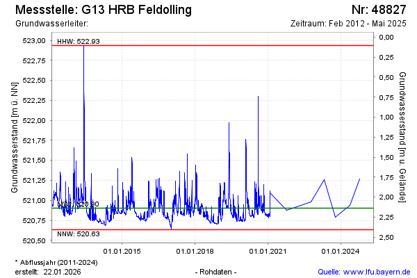
note
Die Messstelle wird nicht mehr beobachtet.
Groundwater level [m above sealevel]: 521.27
Distance to surface [m]: 1.77
Last value from 14.10.2024 10:00
Ground level [m above sealevel]: 523.04
| Date | Groundwater level [m above sealevel] |
|---|---|
| 13.05.2024 | 520.94 |
| 11.10.2023 | 520.79 |
| 02.05.2023 | 521.26 |
| 10.10.2022 | 520.98 |
| 07.10.2021 | 520.88 |
| 06.10.2021 | -- |
| 05.10.2021 | -- |
| 04.10.2021 | -- |
© Bayerisches Landesamt für Umwelt 2025