
- Start >
- Groundwater >
- Waterlevel of upper layer >
- Bayern >
- GÖSSERSDORF (S 2) >
- Current data

Current data GÖSSERSDORF (S 2)
Groundwater levels of the last 12 months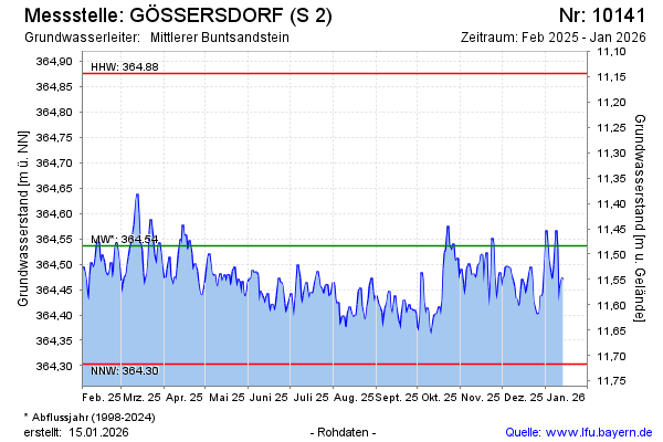
Groundwater level [m above sealevel]: 364.48
Distance to surface [m]: 11.54
Last value from 15.01.2025 09:35
Ground level [m above sealevel]: 376.02
| Date | Groundwater level [m above sealevel] |
|---|---|
| 15.01.2025 | 364.47 |
| 14.01.2025 | 364.45 |
| 13.01.2025 | 364.42 |
| 12.01.2025 | 364.46 |
| 11.01.2025 | 364.52 |
| 10.01.2025 | 364.55 |
| 09.01.2025 | 364.63 |
| 08.01.2025 | 364.60 |
© Bayerisches Landesamt für Umwelt 2025