
- Start >
- Groundwater >
- Waterlevel of upper layer >
- Bayern >
- GWM 11/23 HRB Westerheim WWA Kempten >
- Chart of total period

Chart of total period GWM 11/23 HRB Westerheim WWA Kempten
Groundwater levels of the total period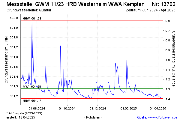
Groundwater level [m above sealevel]: 601.18
Distance to surface [m]: 1.39
Last value from 07.04.2025 09:00
Ground level [m above sealevel]: 602.57
Date | Groundwater level [m above sealevel] |
|---|---|
| 07.04.2025 | 601.18 |
| 06.04.2025 | 601.18 |
| 05.04.2025 | 601.19 |
| 04.04.2025 | 601.19 |
| 03.04.2025 | 601.19 |
| 02.04.2025 | 601.20 |
| 01.04.2025 | 601.20 |
| 31.03.2025 | 601.21 |
© Bayerisches Landesamt für Umwelt 2025