
- Start >
- Groundwater >
- Waterlevel of upper layer >
- Bayern >
- HEISSESHEIM 53 >
- Chart of total period

Chart of total period HEISSESHEIM 53
Groundwater levels of the total period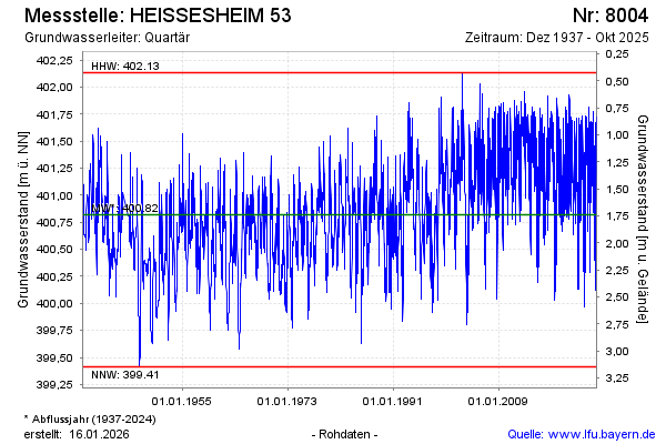
note
Aktualisierung nur alle 3-bis 4 Monate!
Groundwater level [m above sealevel]: 400.74
Distance to surface [m]: 1.82
Last value from 29.07.2024 10:00
Ground level [m above sealevel]: 402.56
| Date | Groundwater level [m above sealevel] |
|---|---|
| 22.07.2024 | 401.09 |
| 15.07.2024 | 401.28 |
| 08.07.2024 | 401.53 |
| 01.07.2024 | 401.67 |
| 24.06.2024 | 401.44 |
| 17.06.2024 | 401.61 |
| 10.06.2024 | 401.75 |
| 03.06.2024 | 401.81 |
© Bayerisches Landesamt für Umwelt 2024