
- Start >
- Groundwater >
- Waterlevel of upper layer >
- Bayern >
- Kühzägl, ehem Hausmülldepnie, Deponie 1 >
- Chart of total period

Chart of total period Kühzägl, ehem Hausmülldepnie, Deponie 1
Groundwater levels of the total period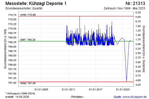
note
Die Messstelle wird nicht mehr beobachtet.
Groundwater level [m above sealevel]: 769.37
Distance to surface [m]: 1.77
Last value from 01.10.2024 10:00
Ground level [m above sealevel]: 771.14
| Date | Groundwater level [m above sealevel] |
|---|---|
| 14.05.2024 | 769.26 |
| 12.10.2023 | 767.05 |
| 04.05.2023 | 769.40 |
| 05.10.2022 | 769.47 |
| 10.05.2022 | 769.37 |
| 12.10.2021 | 769.11 |
| 06.05.2021 | 769.34 |
| 03.02.2021 | 769.53 |
© Bayerisches Landesamt für Umwelt 2024