
- Start >
- Groundwater >
- Waterlevel of upper layer >
- Bayern >
- MAX LINIE 608 >
- Chart of total period

Chart of total period MAX LINIE 608
Groundwater levels of the total period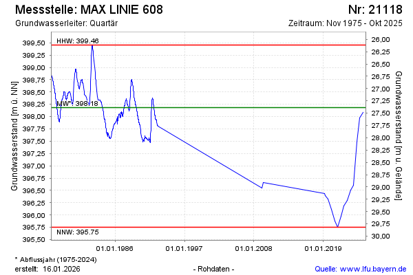
note
Die Messstelle wird nicht mehr beobachtet.
Groundwater level [m above sealevel]: 397.97
Distance to surface [m]: 27.60
Last value from 10.10.2024 12:42
Ground level [m above sealevel]: 425.57
| Date | Groundwater level [m above sealevel] |
|---|---|
| 18.04.2024 | 397.49 |
| 19.10.2023 | 396.60 |
| 19.04.2023 | 396.51 |
| 18.10.2022 | 396.30 |
| 12.04.2022 | 396.19 |
| 12.10.2021 | 395.97 |
| 14.04.2021 | 395.75 |
| 20.10.2020 | 395.88 |
© Bayerisches Landesamt für Umwelt 2024