
- Start >
- Groundwater >
- Waterlevel of upper layer >
- Bayern >
- MITTERWÖHR GR.ISAR 70/63 >
- Current data

Current data MITTERWÖHR GR.ISAR 70/63
Groundwater levels of the last 12 months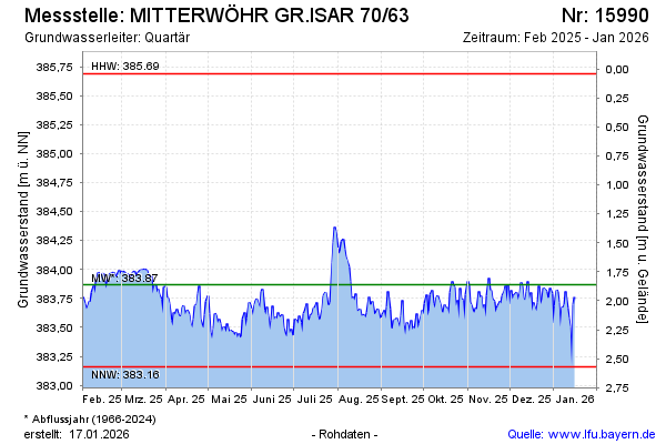
Groundwater level [m above sealevel]: 383.99
Distance to surface [m]: 1.74
Last value from 16.03.2025 10:00
Ground level [m above sealevel]: 385.73
| Date | Groundwater level [m above sealevel] |
|---|---|
| 16.03.2025 | 384.00 |
| 15.03.2025 | 384.00 |
| 14.03.2025 | 383.99 |
| 13.03.2025 | 383.98 |
| 12.03.2025 | 383.96 |
| 11.03.2025 | 383.95 |
| 10.03.2025 | 383.98 |
| 09.03.2025 | 383.98 |
© Bayerisches Landesamt für Umwelt 2025