
- Start >
- Groundwater >
- Waterlevel of upper layer >
- Bayern >
- MITTERWÖHR LIEGNITZER STRASSE >
- Chart of total period

Chart of total period MITTERWÖHR LIEGNITZER STRASSE
Groundwater levels of the total period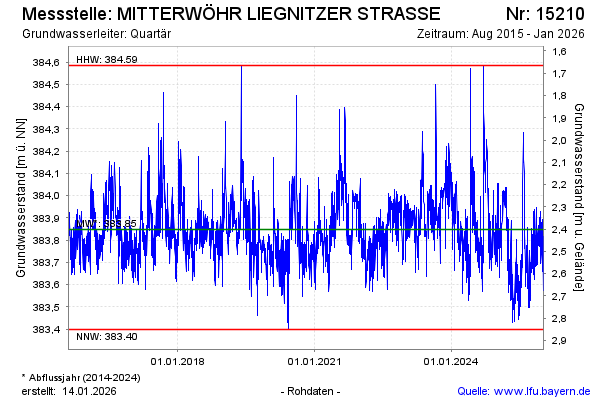
Groundwater level [m above sealevel]: 383.62
Distance to surface [m]: 2.63
Last value from 06.01.2026 10:00
Ground level [m above sealevel]: 386.25
| Date | Groundwater level [m above sealevel] |
|---|---|
| 06.01.2026 | 383.57 |
| 05.01.2026 | 383.87 |
| 04.01.2026 | 383.84 |
| 03.01.2026 | 383.86 |
| 02.01.2026 | 383.67 |
| 01.01.2026 | 383.66 |
| 31.12.2025 | 383.85 |
| 30.12.2025 | 383.89 |
© Bayerisches Landesamt für Umwelt 2026