
- Start >
- Groundwater >
- Waterlevel of upper layer >
- Bayern >
- OBERWOEHR-MANGF.AU 21A >
- Current data

Current data OBERWOEHR-MANGF.AU 21A
Groundwater levels of the last 12 months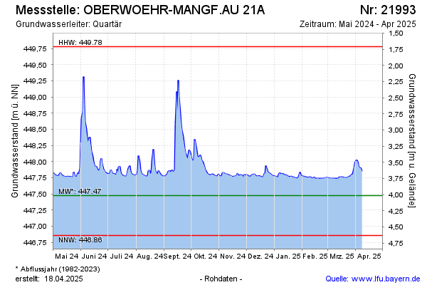
note
Die Messstelle musste 2009 verlegt werden !
Groundwater level [m above sealevel]: 447.95
Distance to surface [m]: 3.54
Last value from 15.10.2024 14:34
Ground level [m above sealevel]: 451.49
| Date | Groundwater level [m above sealevel] |
|---|---|
| 15.10.2024 | 447.96 |
| 14.10.2024 | 447.99 |
| 13.10.2024 | 448.02 |
| 12.10.2024 | 448.07 |
| 11.10.2024 | 448.10 |
| 10.10.2024 | 448.07 |
| 09.10.2024 | 448.07 |
| 08.10.2024 | 448.09 |
© Bayerisches Landesamt für Umwelt 2024