
- Start >
- Groundwater >
- Waterlevel of upper layer >
- Bayern >
- SUEDL.BEHRHOF G4 >
- Chart of total period

Chart of total period SUEDL.BEHRHOF G4
Groundwater levels of the total period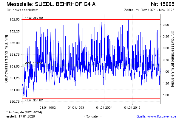
Groundwater level [m above sealevel]: 351.57
Distance to surface [m]: 0.82
Last value from 04.02.2025 13:55
Ground level [m above sealevel]: 352.39
| Date | Groundwater level [m above sealevel] |
|---|---|
| 04.02.2025 | 351.57 |
| 03.02.2025 | 351.59 |
| 02.02.2025 | 351.61 |
| 01.02.2025 | 351.64 |
| 31.01.2025 | 351.67 |
| 30.01.2025 | 351.72 |
| 29.01.2025 | 351.79 |
| 28.01.2025 | 351.67 |
© Bayerisches Landesamt für Umwelt 2025