
- Start >
- Groundwater >
- Waterlevel of upper layer >
- Bayern >
- Thal Nord (Schlössleweg) N7 >
- Current data

Current data Thal Nord (Schlössleweg) N7
Groundwater levels of the last 12 months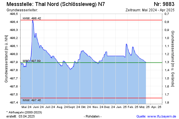
Groundwater level [m above sealevel]: 497.90
Distance to surface [m]: 1.30
Last value from 20.03.2025 09:22
Ground level [m above sealevel]: 499.20
Date | Groundwater level [m above sealevel] |
|---|---|
| 31.12.2024 | 497.97 |
| 30.12.2024 | 497.97 |
| 29.12.2024 | 497.97 |
| 28.12.2024 | 497.97 |
| 27.12.2024 | 497.97 |
| 26.12.2024 | 497.97 |
| 25.12.2024 | 497.97 |
| 24.12.2024 | 497.97 |
© Bayerisches Landesamt für Umwelt 2025