
- Start >
- Groundwater >
- Waterlevel of upper layer >
- Bayern >
- Tiefenstockheim MU 14 >
- Chart of total period

Chart of total period Tiefenstockheim MU 14
Groundwater levels of the total period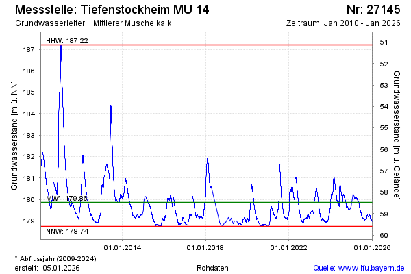
note
Ersatzgerät ist eingebaut. Monatliche Auslesung der Daten.
Groundwater level [m above sealevel]: 180.11
Distance to surface [m]: 58.23
Last value from 10.03.2025 13:00
Ground level [m above sealevel]: 238.34
| Date | Groundwater level [m above sealevel] |
|---|---|
| 10.03.2025 | 180.11 |
| 09.03.2025 | 180.10 |
| 08.03.2025 | 180.09 |
| 07.03.2025 | 180.08 |
| 06.03.2025 | 180.07 |
| 05.03.2025 | 180.06 |
| 04.03.2025 | 180.05 |
| 03.03.2025 | 180.05 |
© Bayerisches Landesamt für Umwelt 2025