
- Start >
- Groundwater >
- Waterlevel of upper layer >
- Bayern >
- WEIHENLINDEN R 11A >
- Chart of total period

Chart of total period WEIHENLINDEN R 11A
Groundwater levels of the total period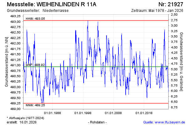
note
Die Messstelle musste 2011 verlegt werden !
Groundwater level [m above sealevel]: 491.47
Distance to surface [m]: 4.35
Last value from 27.11.2024 07:00
Ground level [m above sealevel]: 495.82
| Date | Groundwater level [m above sealevel] |
|---|---|
| 26.11.2024 | 491.49 |
| 25.11.2024 | 491.50 |
| 24.11.2024 | 491.51 |
| 23.11.2024 | 491.52 |
| 22.11.2024 | 491.54 |
| 21.11.2024 | 491.56 |
| 20.11.2024 | 491.57 |
| 19.11.2024 | 491.58 |
© Bayerisches Landesamt für Umwelt 2024