
- Start >
- Groundwater >
- Waterlevel of upper layer >
- Bayern >
- Wullenstetten, Kässbohrer Nord (BGW 2) >
- Chart of total period

Chart of total period Wullenstetten, Kässbohrer Nord (BGW 2)
Groundwater levels of the total period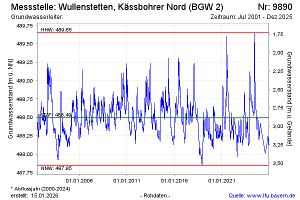
Groundwater level [m above sealevel]: 488.42
Distance to surface [m]: 2.96
Last value from 23.01.2025 10:21
Ground level [m above sealevel]: 491.38
| Date | Groundwater level [m above sealevel] |
|---|---|
| 03.01.2025 | 488.31 |
| 02.01.2025 | 488.31 |
| 01.01.2025 | 488.32 |
| 31.12.2024 | 488.33 |
| 30.12.2024 | 488.34 |
| 29.12.2024 | 488.34 |
| 28.12.2024 | 488.35 |
| 27.12.2024 | 488.35 |
© Bayerisches Landesamt für Umwelt 2025