
- Start >
- Groundwater >
- Waterlevel of upper layer >
- Oberer Main - Elbe >
- Viereth, Hut 193 A >
- Chart of total period

Chart of total period Viereth, Hut 193 A
Groundwater levels of the total period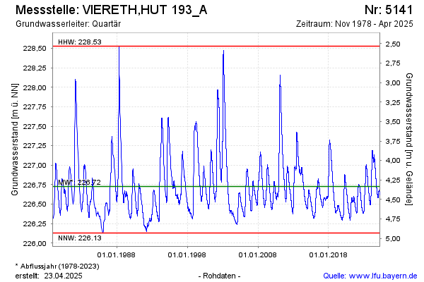
Groundwater level [m above sealevel]: 226.68
Distance to surface [m]: 4.38
Last value from 12.03.2025 09:10
Ground level [m above sealevel]: 231.06
| Date | Groundwater level [m above sealevel] |
|---|---|
| 12.03.2025 | 226.68 |
| 11.03.2025 | 226.67 |
| 10.03.2025 | 226.67 |
| 09.03.2025 | 226.68 |
| 08.03.2025 | 226.67 |
| 07.03.2025 | 226.67 |
| 06.03.2025 | 226.67 |
| 05.03.2025 | 226.67 |
© Bayerisches Landesamt für Umwelt 2025