
- Start >
- Groundwater >
- Waterlevel of upper layer >
- Iller - Lech - Bodensee >
- Sontheim 3/06 >
- Chart of total period

Chart of total period Sontheim 3/06
Groundwater levels of the total period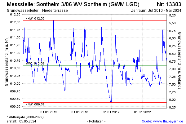
note
Zeitweise Störung der Datenübertragung
Groundwater level [m above sealevel]: 610.63
Distance to surface [m]: 6.84
Last value from 30.11.2024 09:00
Ground level [m above sealevel]: 617.47
| Date | Groundwater level [m above sealevel] |
|---|---|
| 30.11.2024 | 610.63 |
| 29.11.2024 | 610.64 |
| 28.11.2024 | 610.64 |
| 27.11.2024 | 610.65 |
| 26.11.2024 | 610.65 |
| 25.11.2024 | 610.66 |
| 24.11.2024 | 610.67 |
| 23.11.2024 | 610.67 |
© Bayerisches Landesamt für Umwelt 2024