
- Start >
- Groundwater >
- Waterlevel of upper layer >
- Iller - Lech - Bodensee >
- Vöhringen, Emmershofer Weg (101) >
- Chart of total period

Chart of total period Vöhringen, Emmershofer Weg (101)
Groundwater levels of the total period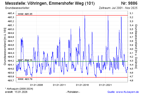
Groundwater level [m above sealevel]: 494.32
Distance to surface [m]: 4.18
Last value from 17.02.2025 11:43
Ground level [m above sealevel]: 498.50
| Date | Groundwater level [m above sealevel] |
|---|---|
| 17.02.2025 | 494.31 |
| 16.02.2025 | 494.31 |
| 15.02.2025 | 494.32 |
| 14.02.2025 | 494.32 |
| 13.02.2025 | 494.31 |
| 12.02.2025 | 494.31 |
| 11.02.2025 | 494.32 |
| 10.02.2025 | 494.32 |
© Bayerisches Landesamt für Umwelt 2025