
- Start >
- Groundwater >
- Waterlevel of upper layer >
- Inn >
- ST. 2078 ARMCO KO 41 >
- Current data

Current data ST. 2078 ARMCO KO 41
Groundwater levels of the last 12 months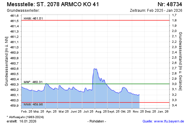
Groundwater level [m above sealevel]: 460.19
Distance to surface [m]: 3.12
Last value from 19.02.2025 11:22
Ground level [m above sealevel]: 463.31
| Date | Groundwater level [m above sealevel] |
|---|---|
| 19.02.2025 | 460.20 |
| 18.02.2025 | 460.20 |
| 17.02.2025 | 460.20 |
| 16.02.2025 | 460.20 |
| 15.02.2025 | 460.21 |
| 14.02.2025 | 460.22 |
| 13.02.2025 | 460.21 |
| 12.02.2025 | 460.21 |
© Bayerisches Landesamt für Umwelt 2025