
- Start >
- Groundwater >
- Waterlevel of upper layer >
- Isar >
- MITTERWÖHR KL.ISAR 70/59 >
- Current data

Current data MITTERWÖHR KL.ISAR 70/59
Groundwater levels of the last 12 months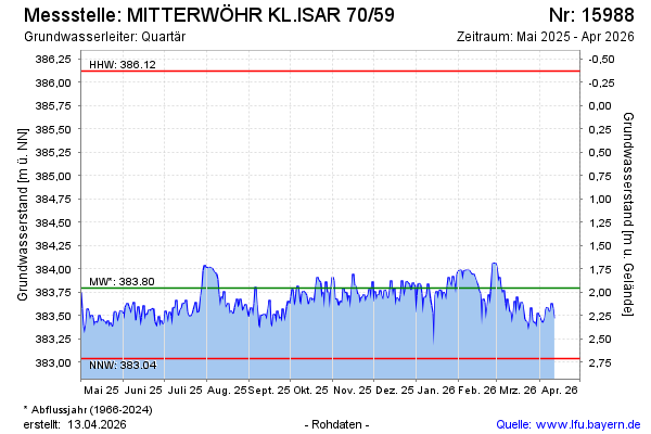
Groundwater level [m above sealevel]: 383.88
Distance to surface [m]: 1.87
Last value from 23.11.2024 10:00
Ground level [m above sealevel]: 385.75
| Date | Groundwater level [m above sealevel] |
|---|---|
| 23.11.2024 | 383.80 |
| 22.11.2024 | 383.70 |
| 21.11.2024 | 383.74 |
| 20.11.2024 | 383.60 |
| 19.11.2024 | 383.57 |
| 18.11.2024 | 383.64 |
| 17.11.2024 | 383.59 |
| 16.11.2024 | 383.63 |
© Bayerisches Landesamt für Umwelt 2024